Nominatim (Reverse Geocoder) via PL/PYTHON for RubyOnRails Mapping App
Even google maps enterprise have restrictions on their geocoding/reverse-geocoding services, 100k if my memory serves me correctly. So, I have to rollout our own service to allow millions of lonlats for reverse geocoding. Have a look at Nominatim, yes it’s opensource. If you need to get it up and running, have a read of my nominatim installation via homebrew on OSX.
The nominatim www interface which spits out xml/json depending on the format parameter is done in php.
Anyway, I wanted to expose/use this webservice for our Rails3 app. It will also be good if we don’t use the nominatim webservice all the time if the lonlat was already requested–caching.
Python-Nominatim https://github.com/rdeguzman/python-nominatim
This project was forked from Austin’s Gabels python-nominatim. I added the ability to pass a base_url to the classes and added reverse_geocode.py. So assuming you have Python installed, you can do a reverse geocode like this…
from nominatim import ReverseGeocoder client = ReverseGeocoder("http://127.0.0.1/nominatim/reverse.php?format=json") response = client.geocode(-37.856206, 145.233980) print response['full_address'] #Amesbury Avenue, Wantirna, City of Knox, 3152, Australia |
PL/PYTHON
Now we wrap this python code via PL/PYTHON so Postgres can call it. Checkout setup.sql
CREATE PROCEDURAL LANGUAGE 'plpythonu' HANDLER plpython_call_handler; CREATE OR REPLACE FUNCTION reverse_geocode(geocoding_url text, latitude FLOAT, longitude FLOAT) RETURNS text AS $$ import nominatim client = nominatim.ReverseGeocoder(geocoding_url) response = client.geocode(latitude, longitude) RETURN response['full_address'] $$ LANGUAGE 'plpythonu'; |
With the snippet above, we can now call this with a regular SELECT statement…
SELECT reverse_geocode('http://127.0.0.1/nominatim/reverse.php?format=json', -37.856206, 145.233980); reverse_geocode ---------------------------------------------------------- Amesbury Avenue, Wantirna, City OF Knox, 3152, Australia (1 ROW) |
Rails ActiveRecord
create_table :locations do |t| t.float :latitude t.float :longitude t.text :address end |
In AR, I created a location model above and exposed a reverse_geocode method below
class Location < ActiveRecord::Base def self.reverse_geocode(geocode_url, lat, lon) sql_string = "SELECT reverse_geocode('#{geocode_url}', #{lat}, #{lon}) as address, #{lat} as latitude, #{lon} as longitude" loc_array = self.find_by_sql sql_string loc_array[] end end |
So now, in one of my models, I could simply do..
class ActiveSession < ActiveRecord::Base ... def location_address if self.has_gps? loc = Location.reverse_geocode('http://path/to/reverse.php?format=json', self.gps_latitude, self.gps_longitude) loc.address else nil end end ... end |
In the view, we can simple call model.location_address to retrieve the location details. Below is a code snippet which creates a google marker and adds the location details in the infoWindow.
<% location = active_session.location_address %> var latlong = new google.maps.LatLng(<%= active_session.gps_latitude %>, <%= active_session.gps_longitude %>); var content = '<div style="width: 300px;">'; content = content + '<p><%= escape_javascript location %></p>'; content = content + '<p><%= active_session.gps_longitude %>,<%= active_session.gps_latitude %></p>'; |
Caching
Our last step is to improve performance via caching. I have opted to do this from the PL/PYTHON end but using a Rails activerecord model/table. This way, the Rails activerecord has no idea that it is cached when it calls model.location_address. Below, I wrap the new reverse_geocode PL/PYTHON function in a rails migration.
class CreateFunctionReverseGeocoder < ActiveRecord::Migration ActiveRecord::Base.connection.schema_search_path = "public" def self.up execute 'CREATE OR REPLACE FUNCTION reverse_geocode(geocoding_url text, latitude float, longitude float) RETURNS text AS $$ plan = plpy.prepare("SELECT address FROM locations WHERE latitude = $1 AND longitude = $2", [ "float", "float" ]) rv = plpy.execute(plan, [ latitude, longitude ], 1) if rv.nrows() > 0: result = rv[0]["address"] else: import nominatim client = nominatim.ReverseGeocoder(geocoding_url) response = client.geocode(latitude, longitude) result = response["full_address"] insert_plan = plpy.prepare("INSERT INTO locations(latitude, longitude, address) VALUES($1, $2, $3)", ["float", "float", "text"]) plpy.execute(insert_plan, [ latitude, longitude, result ]) return result $$ language plpythonu;' end def self.down execute 'DROP FUNCTION IF EXISTS reverse_geocode(text, double precision, double precision);' end end |
Benchmarks
I plotted 1000 records on my MBP (old core2duo early 2009 4GB RAM). Initial launch takes 108 seconds to load, ~ 2 minutes? But subsequent requests loads < 2 secs.
For 1000 records: Completed 200 OK in 110478ms (Views: 1608.8ms | ActiveRecord: 108674.6ms) Completed 200 OK in 1744ms (Views: 1110.7ms | ActiveRecord: 443.3ms) |
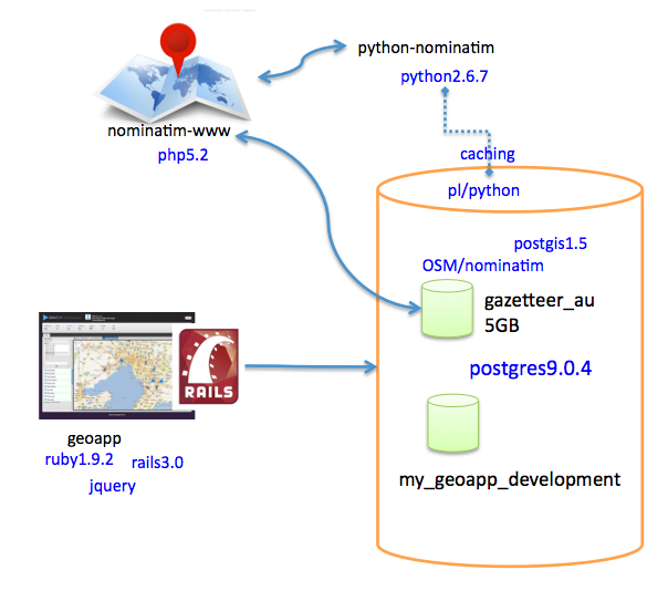
Below is an architecture diagram of how the systems talk to each other. The locations cache is inside the geo_app_development db. Ofcourse, the nominatim database (gazetteer_au) is separate from our domain so it goes into a different db/server whereever.